Tim Spitzack
Editor
When residents rattle off the geographical amenities of Minnesota, you’ll hear them mention our 10,000 lakes, the Boundary Waters Canoe Area, Lake Superior and the Mississippi River. You might even hear some talk about caves, but rarely, if ever, will anyone say canyons. That’s because we don’t have them, at least that’s what I thought until I read about a slot canyon in Crosby Farm Regional Park in St. Paul. Intrigued, I had to see it for myself.
A slot canyon is a long, narrow channel or drainageway with sheer rock walls made of sandstone or other sedimentary rock. They’re common in Utah, Arizona and other areas of the Southwest that get little rainfall. I’ve hiked through some in that region, and they are stunning to see. Their depth-to-width ratios range from 10:1 to nearly 100:1, and some can measure less than 3 feet across at the top and drop more than 100 feet to the canyon floor.
It turns out we have other canyons, too, including the mile-long Kadunce Canyon on the North Shore, north of Grand Marais. Perhaps I’ve been living under a rock.
The bluffs in St. Paul are well known for their many caves, but not canyons. Nonetheless, if you’re willing to walk about one mile from the west entrance parking lot at Crosby Farm, near the marina, you can witness St. Paul’s very own slot canyon for yourself.
The park surrounds two lakes – Crosby Lake and Upper Lake – and has nearly 7 miles of trails that weave through the heavily wooded flood plain of the Mississippi. You can find the canyon by following the trail along the bluff on the north side of the lakes. It’s paved until just past where the two lakes meet, then it becomes a narrow dirt path that is prone to flooding in the springtime. Here, you’ll find a wonderful slice of wilderness. Looking to the south, all that is visible are the shimmering lakes and tangled forestland. Were it not for the din of traffic zooming along Shepard Road on top of the bluff, it would be easy to get lost in a daydream of experiencing the land before a sprawling city grew around it.
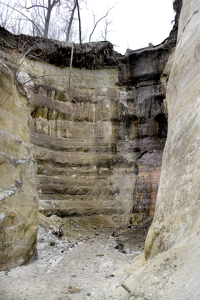
I hiked to the canyon in late February, so it was simple to spot. It may not be as easy to find when the trees are thick with foliage. From the trail you can see the narrow opening of the canyon and one must hike over a slight incline paved with slippery stones to reach it. At its narrowest point, the canyon is just three feet wide and over 30 feet high. Along the walls are initials inscribed by young lovers and others wanting to mark their place in time. Erosion will eventually erase their marks, leaving a clean slate for the next generation. The canyon widens to a large bowl some 20 feet wide and at least twice as high. A trickle of water runs off the bluff and sparkles against the north canyon wall as it makes its way below. All around one can see the colorful strata of the limestone and the many curves and crevices carved out by the passage of time.
Is the canyon as impressive as those in the southwest. No, not by a long shot, but it’s still interesting to see and is worth the short hike. Plus, it gives us one more boast of the many wonderful geographical amenities we have in our state.
For more information on Crosby Farm Regional Park, visit stpaul.gov/facilities/crosby-farm-regional-park.
<<< Back to Home


